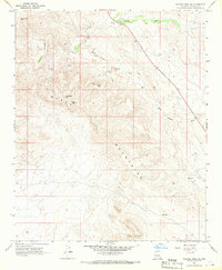
1967 Map of Malpais Mesa SW
USGS Topo · Published 1970About this map
The Santa Maria River carves through the northwestern corner of this high-desert landscape, where the Black Mountains dominate the central and southern terrain. This 1960s survey captures a region defined by remote mining activity and scattered water sources essential for survival in the arid Yavapai County backcountry. The industrial footprint of the era is evidenced by the Big Stick Mine and a Borrow Pit located near the northeast drainage.
Find a feature on this map
20 named features on this map. Tap any name to fly to it.
Don’t see what you’re looking for? This feature index may not catch every label — zoom into the map to look around manually.
Map Details
Editions of this 1967 Malpais Mesa SW Map
This is the sole edition of this map. No revisions or reprints were ever made.
Other maps of this area

1923 · Signal
USGS Topo · 1:250,000

1942 · Signal
USGS Topo · 1:250,000

1950 · Prescott
USGS Topo · 1:250,000

1954 · Prescott
USGS Topo · 1:250,000

1958 · Prescott
USGS Topo · 1:250,000

1959 · Prescott
USGS Topo · 1:250,000

1960 · Prescott
USGS Topo · 1:250,000

1965 · Prescott
USGS Topo · 1:250,000
1967 · Date Creek Ranch NW
USGS Topo · 1:24,000
1967 · Arrastra Mtn SE
USGS Topo · 1:24,000