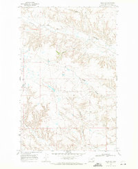
1968 Map of Malta NW
USGS Topo · Published 1971About this map
Assiniboine Creek and its seasonal drainage network define the topography of this corner of Phillips County during the late 1960s. The landscape is characterized by intricate coulees and forks, including the Dry Fork Assiniboine Creek and the meandering path of Spring Coulee. This USGS study, based on 1967 aerial photography, captures the rural character of the Montana plains before significant modern land-use changes. To the south, Beaver Creek and Wilson Coulee carve through the terrain, while small-scale industrial activity is evidenced by a Gravel Pit near the southern boundary. The map serves as a precise record of the hydrological features and local drainage patterns essential to the ranching and agricultural life of the region.
Find a feature on this map
6 named features on this map. Tap any name to fly to it.
Don’t see what you’re looking for? This feature index may not catch every label — zoom into the map to look around manually.
Map Details
Editions of this 1968 Malta NW Map
This is the sole edition of this map. No revisions or reprints were ever made.
Other maps of this area

1920 · Avery
USGS Topo · 1:125,000

1920 · Cowan
USGS Topo · 1:125,000

1953 · Havre
USGS Topo · 1:250,000

1954 · Glasgow
USGS Topo · 1:250,000

1957 · Glasgow
USGS Topo · 1:250,000

1957 · Havre
USGS Topo · 1:250,000

1958 · Glasgow
USGS Topo · 1:250,000

1958 · Havre
USGS Topo · 1:250,000

1964 · Dodson NE
USGS Topo · 1:24,000

1965 · Wagner
USGS Topo · 1:24,000