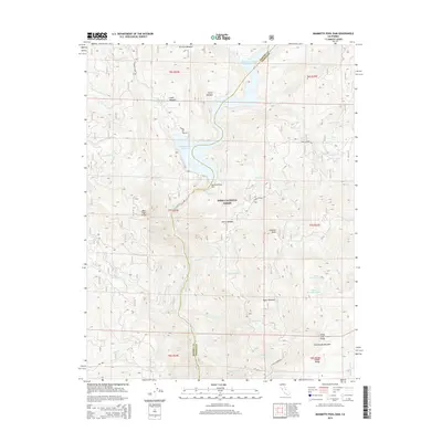
2015 Map of Mammoth Pool Dam
USGS Topo · Published 2015About this map
Mammoth Pool Reservoir and the Mammoth Pool Dam dominate this section of the Sierra Nevada high country, where the borders of Madera and Fresno counties meet. The landscape is defined by the steep canyon of the San Joaquin River and its numerous tributaries, including Jackass Cr and Chiquito Cr. Located within the Sierra National Forest, the terrain rises toward Kaiser Ridge in the southeast, reaching landmarks like Lookout Point and the steep Jump Off Point. High-altitude meadows such as Logan Meadow, Fuller Meadow, and Aspen Meadow break up the timbered slopes. Transportation through this remote area is limited to established routes like Mammoth Pool Rd and Stump Springs Rd, which provide access to the reservoir and the dramatic bend at Mile High Curve.
Find a feature on this map
43 named features on this map. Tap any name to fly to it.
Don’t see what you’re looking for? This feature index may not catch every label — zoom into the map to look around manually.
Map Details
Editions of this 2015 Mammoth Pool Dam Map
This is the sole edition of this map. No revisions or reprints were ever made.
Other maps of this area

1904 · Kaiser
USGS Topo · 1:125,000

1947 · Mariposa
USGS Topo · 1:250,000

1948 · Mariposa
USGS Topo · 1:250,000

1953 · Huntington Lake
USGS Topo · 1:62,500

1953 · Shaver Lake
USGS Topo · 1:62,500

1953 · Shuteye Peak
USGS Topo · 1:62,500

1953 · Kaiser Peak
USGS Topo · 1:62,500

1957 · Mariposa
USGS Topo · 1:250,000

1963 · Mariposa
USGS Topo · 1:250,000

1980 · Shaver Lake
USGS Topo · 1:100,000