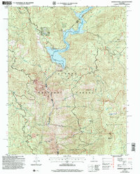
2004 Map of Mammoth Pool Dam
USGS Topo · Published 2007About this map
The San Joaquin River carves a deep path through this section of the Sierra National Forest, dominated by the engineering and recreational hub of the Mammoth Pool Reservoir. Established as part of the regional hydroelectric network, the reservoir is anchored by the Mammoth Pool Dam and its significant Spillway 3337. Along the western shores, local landmarks like Wagner's Mammoth Pool Resort and Logan Meadow mark areas of human activity within the forest. To the east, the terrain ascends toward the high-elevation lakes and peaks of the Kaiser Wilderness, including Upper Horsethief Lake. Traces of the region's extractive and service history appear at the Wieseman Mine and Daulton Station, while the Minarets Scenic Byway and Mammoth Pool Road provide the primary access through this complex landscape of meadows and steep drainage basins.
Find a feature on this map
39 named features on this map. Tap any name to fly to it.
Don’t see what you’re looking for? This feature index may not catch every label — zoom into the map to look around manually.
Map Details
Editions of this 2004 Mammoth Pool Dam Map
This is the sole edition of this map. No revisions or reprints were ever made.
Other maps of this area

1904 · Kaiser
USGS Topo · 1:125,000

1947 · Mariposa
USGS Topo · 1:250,000

1948 · Mariposa
USGS Topo · 1:250,000

1953 · Huntington Lake
USGS Topo · 1:62,500

1953 · Shaver Lake
USGS Topo · 1:62,500

1953 · Shuteye Peak
USGS Topo · 1:62,500

1953 · Kaiser Peak
USGS Topo · 1:62,500

1957 · Mariposa
USGS Topo · 1:250,000

1963 · Mariposa
USGS Topo · 1:250,000

1980 · Shaver Lake
USGS Topo · 1:100,000