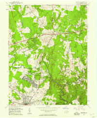
1957 Map of Manassas
USGS Topo · Published 1958About this map
Manassas and Clifton sit at the center of this mid-century portrait of Northern Virginia, showing a landscape on the cusp of significant suburban transformation. The expansion of residential pockets like Manassas Park, Yorkshire, and Stonewall Acres contrasts with the established agricultural patterns of Centreville Farms and Marshall Farms. This 1957 survey documents the critical transportation corridors of the era, including the Southern railroad line and Lee Highway, which facilitated the region's rapid postwar growth. Local social infrastructure is well-defined by a network of rural churches such as Rock Hill Ch, St Johns Ch, and the Centreville Tabernacle. The map also captures specific industrial and institutional sites of the period, from a Quarry near Manassas to the State Prison Camp and the Drive-in Theater near Yorkshire Acres, offering a detailed look at the land use before modern sprawl.
Find a feature on this map
53 named features on this map. Tap any name to fly to it.
Don’t see what you’re looking for? This feature index may not catch every label — zoom into the map to look around manually.
Map Details
Editions of this 1957 Manassas Map
2 editions found
Other maps of this area

1890 · Mt. Vernon
USGS Topo · 1:125,000

1891 · Mt. Vernon
USGS Topo · 1:125,000

1894 · Warrenton
USGS Topo · 1:125,000

1894 · Mt. Vernon
USGS Topo · 1:125,000

1897 · Mt. Vernon
USGS Topo · 1:125,000

1915 · Fairfax
USGS Topo · 1:62,500

1927 · Quantico
USGS Topo · 1:62,500

1933 · Middleburg
USGS Topo · 1:62,500

1940 · Quantico
USGS Topo · 1:62,500

1943 · Quantico
USGS Topo · 1:62,500