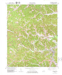
1979 Map of Manchester
USGS Topo · Published 1979About this map
Manchester serves as the focal point for this late 1970s survey of Clay County, showing a landscape defined by the extraction economy and the winding path of Goose Creek. The city's growth is visible through landmarks like the Clay County Vocational Sch and Manchester Memorial Gardens, while the Louisville and Nashville railroad and Daniel Boone Toll Road provide the primary transport corridors for the region's coal and timber.
Find a feature on this map
61 named features on this map. Tap any name to fly to it.
Don’t see what you’re looking for? This feature index may not catch every label — zoom into the map to look around manually.
Map Details
Editions of this 1979 Manchester Map
This is the sole edition of this map. No revisions or reprints were ever made.
Other maps of this area

1891 · Manchester
USGS Topo · 1:125,000

1952 · Portersburg
USGS Topo · 1:24,000

1952 · Hima
USGS Topo · 1:24,000

1952 · Blackwater
USGS Topo · 1:24,000

1952 · Manchester
USGS Topo · 1:24,000

1953 · Oneida
USGS Topo · 1:24,000

1953 · Tyner
USGS Topo · 1:24,000

1954 · Barcreek
USGS Topo · 1:24,000

1954 · Maulden
USGS Topo · 1:24,000
1954 · Ogle
USGS Topo · 1:24,000