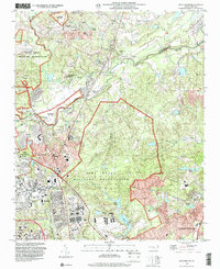
1997 Map of Manchester
USGS Topo · Published 2000About this map
The Fort Bragg Military Reservation and Pope Air Force Base dominate this late-20th-century landscape, illustrating the deep integration of military operations with the surrounding Sandhills communities. The topography, based on imagery updated through 1997, reveals a complex network of defense infrastructure including Simmons Airfield, an Athletic Field, and a large Hospital complex. Along the banks of the Little River, the settlement of Manchester sits near the base boundary, while to the south, Spring Lake shows significant residential density and commercial development, including a Drive-in Theater and numerous Mobile Home Parks.
Find a feature on this map
36 named features on this map. Tap any name to fly to it.
Don’t see what you’re looking for? This feature index may not catch every label — zoom into the map to look around manually.
Map Details
Editions of this 1997 Manchester Map
This is the sole edition of this map. No revisions or reprints were ever made.
Other maps of this area

1948 · Fayetteville
USGS Topo · 1:62,500

1948 · Clifdale
USGS Topo · 1:62,500

1948 · Slocomb
USGS Topo · 1:24,000

1948 · Clifdale
USGS Topo · 1:24,000

1949 · Vander
USGS Topo · 1:24,000

1950 · Clifdale
USGS Topo · 1:24,000

1950 · Fayetteville
USGS Topo · 1:24,000

1950 · Manchester
USGS Topo · 1:24,000

1950 · Slocomb
USGS Topo · 1:24,000

1951 · Clifdale
USGS Topo · 1:62,500
Featured Places
- Fayetteville, NC
- Spring Lake, NC
- Woodbridge, NC
- Corregidor Courts/Bouganville, Fort Liberty
- Pope Field, NC