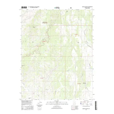
2017 Map of Mancos Jim Butte
USGS Topo · Published 2017About this map
Blanding sits at the edge of a dramatic canyon landscape in San Juan County, where the high desert meets the southern reaches of the Manti-Lasal National Forest. This 2017 survey details the complex network of drainages and mesas, dominated by the prominent Mancos Jim Butte and the eroding formations of Brushy Basin. The township's water infrastructure is clearly visible through the Blanding City Reservoirs and the course of Johnson Creek, which feeds into the deep Big Canyon. To the west, the terrain rises toward unique landmarks like the Bee Hives and Black Steer Knoll, while the Brushy Basin Rim provides a sharp natural boundary. The map documents modern forest access via Forest Rd 092 and local routes like Cedar Edge Ln, showing how the community of Blanding is physically tied to the surrounding canyon systems.
Find a feature on this map
25 named features on this map. Tap any name to fly to it.
Don’t see what you’re looking for? This feature index may not catch every label — zoom into the map to look around manually.
Map Details
Editions of this 2017 Mancos Jim Butte Map
This is the sole edition of this map. No revisions or reprints were ever made.
Other maps of this area

1886 · Abajo
USGS Topo · 1:250,000

1892 · Abajo
USGS Topo · 1:250,000

1893 · Abajo
USGS Topo · 1:250,000

1935 · Elk Ridge
USGS Topo · 1:96,000

1940 · Elk Ridge
USGS Topo · 1:125,000

1954 · Elk Ridge 4 NW
USGS Topo · 1:24,000

1954 · Elk Ridge 1 SW
USGS Topo · 1:24,000

1954 · Elk Ridge 1 SE
USGS Topo · 1:24,000
1954 · Mt Linnaeus
USGS Topo · 1:62,500

1956 · Cortez
USGS Topo · 1:250,000