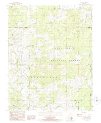
1987 Map of Manes
USGS Topo · Published 1987About this map
Manes and its surrounding countryside in Wright County appear here in a detailed snapshot of rural Missouri life from the late 1980s. The landscape is defined by the extensive reaches of the Mark Twain National Forest, which blankets much of the eastern and central territory. Small, dispersed settlements like Lynchburg, Mingsville, and Embree serve as the primary hubs for local residents, connected by a network of winding roads and paths. These communities are closely tied to the area's drainage systems, with Beaver Creek and Mill Creek carving through the terrain. The topography is further punctuated by deep hollows, such as Schoolhouse Hollow and Wolf Hollow, which reveal the local character of the Ozark Plateau. Genealogists will find the location of a local Cem and isolated homesteads helpful for tracing family residency in this portion of Gasconade and Montgomery townships.
Find a feature on this map
21 named features on this map. Tap any name to fly to it.
Don’t see what you’re looking for? This feature index may not catch every label — zoom into the map to look around manually.
Map Details
Editions of this 1987 Manes Map
This is the sole edition of this map. No revisions or reprints were ever made.
Other maps of this area

1931 · Manes
USGS Topo · 1:48,000

1941 · Big Piney
USGS Topo · 1:62,500

1941 · Manes
USGS Topo · 1:62,500

1941 · Bado
USGS Topo · 1:62,500

1943 · Big Piney
USGS Topo · 1:62,500

1943 · Manes
USGS Topo · 1:62,500

1943 · Drynob
USGS Topo · 1:62,500

1943 · Bado
USGS Topo · 1:62,500

1954 · Springfield
USGS Topo · 1:250,000

1954 · Drynob
USGS Topo · 1:62,500