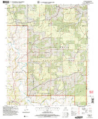
2004 Map of Manes
USGS Topo · Published 2006About this map
Mark Twain National Forest dominates the topography of this central Missouri landscape, where the ridges and hollows of Wright and Laclede counties converge. The map documents several small, persistent communities including Manes, Lynchburg, and Embree, alongside the site of the former Lynchburg CCC Camp. This area is defined by its complex drainage network, where Beaver Creek and Norris Creek wind through deep depressions like Wolf Hollow and Moore Hollow. The presence of a Schoolhouse and numerous small cemeteries marked simply as Cem across the hillsides suggests a history of dispersed rural settlement and family homesteads typical of the Ozark plateau. The network of backroads, including Blackwell Road and Mosely Road, provides a clear view of the local infrastructure during the early 21st century revision by the USDA Forest Service.
Find a feature on this map
26 named features on this map. Tap any name to fly to it.
Don’t see what you’re looking for? This feature index may not catch every label — zoom into the map to look around manually.
Map Details
Editions of this 2004 Manes Map
This is the sole edition of this map. No revisions or reprints were ever made.
Other maps of this area

1931 · Manes
USGS Topo · 1:48,000

1941 · Big Piney
USGS Topo · 1:62,500

1941 · Manes
USGS Topo · 1:62,500

1941 · Bado
USGS Topo · 1:62,500

1943 · Big Piney
USGS Topo · 1:62,500

1943 · Manes
USGS Topo · 1:62,500

1943 · Drynob
USGS Topo · 1:62,500

1943 · Bado
USGS Topo · 1:62,500

1954 · Springfield
USGS Topo · 1:250,000

1954 · Drynob
USGS Topo · 1:62,500