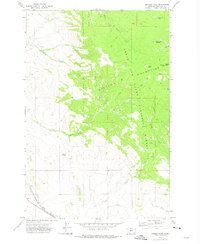
1971 Map of Manger Park
USGS Topo · Published 1975About this map
The Castle Mountains dominate this 1971 survey of Meagher County, where the high-altitude terrain of the Lewis and Clark National Forest transitions into the productive valley floors below. The southwestern corner of the map features a critical piece of regional infrastructure: the White Sulphur Springs and Yellowstone Park Railway, which runs parallel to the Smith River and the South Fork Smith River. This rail connection was historically vital for moving livestock and resources out of this high-country landscape.
Find a feature on this map
25 named features on this map. Tap any name to fly to it.
Don’t see what you’re looking for? This feature index may not catch every label — zoom into the map to look around manually.
Map Details
Editions of this 1971 Manger Park Map
This is the sole edition of this map. No revisions or reprints were ever made.
Other maps of this area

1886 · Little Belt Mts.
USGS Topo · 1:250,000

1894 · Little Belt Mts.
USGS Topo · 1:250,000

1897 · Little Belt Mts.
USGS Topo · 1:250,000

1898 · Little Belt Mts.
USGS Topo · 1:250,000

1902 · Little Belt Mts.
USGS Topo · 1:250,000

1948 · White Sulphur Springs
USGS Topo · 1:250,000

1951 · Hamen
USGS Topo · 1:24,000
1951 · Ringling
USGS Topo · 1:24,000
1951 · Black Butte Mountain
USGS Topo · 1:24,000

1958 · White Sulphur Springs
USGS Topo · 1:250,000