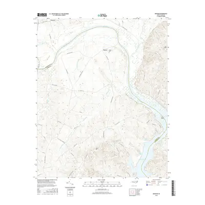
2016 Map of Mangum
USGS Topo · Published 2016About this map
The Pee Dee River carves a dramatic sweep through the borderlands of Anson and Richmond counties, defining the character of this rural landscape. The settlement of Ingram serves as a central point for the surrounding highlands, including the prominent Ingram Mtn. For those tracing local families, the Joseph Ingram Cem remains a significant genealogical landmark. To the south, the terrain descends toward the waters of Blewett Falls Lake, where Petty Gulf and Bell Pond mark the intricate shoreline. The map reveals a network of older transportation routes like Old Stanback Ferry Rd and Smith Ferry Rd, reflecting a period when river crossings were vital to local commerce. In the northern reaches near Mangum, the confluence of the Little River and the Pee Dee highlights the importance of these waterways to the region's geography.
Find a feature on this map
55 named features on this map. Tap any name to fly to it.
Don’t see what you’re looking for? This feature index may not catch every label — zoom into the map to look around manually.
Map Details
Editions of this 2016 Mangum Map
This is the sole edition of this map. No revisions or reprints were ever made.
Other maps of this area

1941 · Spartanburg
USGS Topo · 1:250,000

1942 · Troy
USGS Topo · 1:125,000

1942 · Rockingham
USGS Topo · 1:125,000

1953 · Florence
USGS Topo · 1:250,000

1953 · Raleigh
USGS Topo · 1:250,000

1953 · Spartanburg
USGS Topo · 1:250,000

1953 · Charlotte
USGS Topo · 1:250,000

1954 · Charlotte
USGS Topo · 1:250,000

1954 · Florence
USGS Topo · 1:250,000

1954 · Raleigh
USGS Topo · 1:250,000