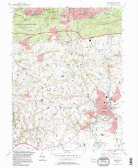
1995 Map of Manheim
USGS Topo · Published 1996About this map
Manheim serves as the primary hub in this mid-1990s survey, showing its dense residential layout and industrial footprint along Chickies Creek. The borough is surrounded by agricultural hamlets and crossroads communities like Sporting Hill, Naumanstown, and Mastersonville. To the north, the terrain rises into the Cornwall Hills, where the Governor Dick Fire Tower stands as a prominent landmark within the wooded slopes of State Game Lands No 145.
Find a feature on this map
73 named features on this map. Tap any name to fly to it.
Don’t see what you’re looking for? This feature index may not catch every label — zoom into the map to look around manually.
Map Details
Editions of this 1995 Manheim Map
This is the sole edition of this map. No revisions or reprints were ever made.
Other maps of this area

1891 · Lebanon
USGS Topo · 1:62,500

1892 · Hummelstown
USGS Topo · 1:62,500

1893 · Lebanon
USGS Topo · 1:62,500

1899 · Lebanon
USGS Topo · 1:62,500

1902 · Lancaster
USGS Topo · 1:62,500

1904 · Lancaster
USGS Topo · 1:62,500

1908 · Middletown
USGS Topo · 1:62,500

1924 · Hummelstown
USGS Topo · 1:62,500

1943 · Lancaster
USGS Topo · 1:62,500

1943 · Lebanon
USGS Topo · 1:62,500