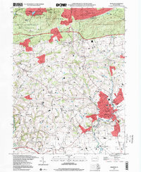
1997 Map of Manheim
USGS Topo · Published 2000About this map
Manheim serves as the central hub of this late-twentieth-century landscape, where a dense network of local schools like the Burgard Sch and High Sch meet the sprawling residential growth of Elwyn Terrace. The terrain north of the borough rises toward the Cornwall Hills, dominated by the recreational and conservation lands of State Game Lands No 145 and State Game Lands No 156. This transition from the industrial and residential core of Manheim to the wooded elevations of Governor Dick Hill reflects the region's enduring balance between agrarian roots and mid-century suburbanization.
Find a feature on this map
69 named features on this map. Tap any name to fly to it.
Don’t see what you’re looking for? This feature index may not catch every label — zoom into the map to look around manually.
Map Details
Editions of this 1997 Manheim Map
This is the sole edition of this map. No revisions or reprints were ever made.
Other maps of this area

1891 · Lebanon
USGS Topo · 1:62,500

1892 · Hummelstown
USGS Topo · 1:62,500

1893 · Lebanon
USGS Topo · 1:62,500

1899 · Lebanon
USGS Topo · 1:62,500

1902 · Lancaster
USGS Topo · 1:62,500

1904 · Lancaster
USGS Topo · 1:62,500

1908 · Middletown
USGS Topo · 1:62,500

1924 · Hummelstown
USGS Topo · 1:62,500

1943 · Lancaster
USGS Topo · 1:62,500

1943 · Lebanon
USGS Topo · 1:62,500