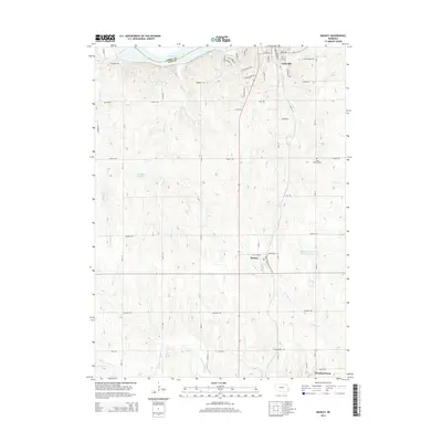
2014 Map of Manley
USGS Topo · Published 2014About this map
Manley and Louisville define the agricultural landscape of this Cass County region, where the Platte River forms a natural northern boundary between Cass and Sarpy counties. The terrain is deeply etched by a network of drainage systems, including Fountain Cr, Mill Cr, and S Cedar Cr, which feed into the larger Weeping Water Cr corridor to the south. This 2014 survey reveals the rural layout of modern farming operations, notably marked by the Midwestern Feeding Company Reservoir and the Luetchens Reservoir. Genealogists and local historians can pinpoint Saint Patricks Cem located along Church Rd, providing a specific geographical anchor for family research. The settlement patterns follow a traditional grid of named country roads, such as Mynard Rd and Mahoney Rd, illustrating the persistence of late-20th-century land divisions into the early 21st century.
Find a feature on this map
53 named features on this map. Tap any name to fly to it.
Don’t see what you’re looking for? This feature index may not catch every label — zoom into the map to look around manually.
Map Details
Editions of this 2014 Manley Map
This is the sole edition of this map. No revisions or reprints were ever made.
Other maps of this area

1893 · Fremont
USGS Topo · 1:125,000

1896 · Fremont
USGS Topo · 1:125,000

1903 · Weeping Water
USGS Topo · 1:125,000

1929 · Weeping Water
USGS Topo · 1:125,000

1955 · Fremont
USGS Topo · 1:250,000

1955 · Lincoln
USGS Topo · 1:250,000

1956 · Cedar Creek
USGS Topo · 1:24,000

1956 · Springfield
USGS Topo · 1:24,000
1956 · Weeping Water NE
USGS Topo · 1:24,000

1957 · Fremont
USGS Topo · 1:250,000