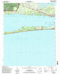
1994 Map of Mansfield
USGS Topo · Published 1998About this map
Bogue Sound and the Intracoastal Waterway separate the mainland settlements of Mansfield and Wildwood from the barrier island developments along Bogue Banks. This mid-1990s revision reveals a landscape defined by conservation and recreation, where the Theodore Roosevelt Natural Area and Hoop Pole Woods preserve pockets of maritime forest amidst the expanding residential footprints of Pine Knoll Shores and Atlantic Beach.
Find a feature on this map
32 named features on this map. Tap any name to fly to it.
Don’t see what you’re looking for? This feature index may not catch every label — zoom into the map to look around manually.
Map Details
Editions of this 1994 Mansfield Map
3 editions found
Other maps of this area

1949 · Beaufort
USGS Topo · 1:24,000

1949 · Newport
USGS Topo · 1:24,000

1949 · Salter Path
USGS Topo · 1:24,000

1949 · Mansfield
USGS Topo · 1:24,000

1949 · Core Creek
USGS Topo · 1:24,000

1949 · Masontown
USGS Topo · 1:24,000

1951 · Salter Path
USGS Topo · 1:24,000

1951 · Newport
USGS Topo · 1:24,000

1951 · Core Creek
USGS Topo · 1:24,000
1951 · Peltier Creek
USGS Topo · 1:24,000