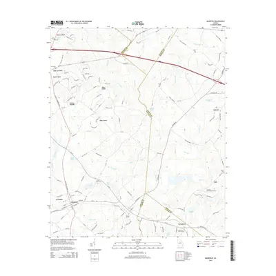
2014 Map of Mansfield
USGS Topo · Published 2014About this map
The town of Mansfield serves as a central hub in this landscape where Walton, Newton, Jasper, and Morgan Counties converge. The area is defined by a dense network of watercourses, including the Little River, Shoal Creek, and the winding Dennis Creek, which feed into numerous local impoundments like Hays Pond, Mores Pond, and Stokes Lake. This 2014 survey reveals a transition from traditional rural settlements such as Jerusalem and Broughton to newer residential developments like Surry Chase, Willow Woods, and Deer Track. Genealogy researchers will find significant value in the distribution of family-named burial sites, including the Perry Family Cemetery, Sewell Cemetery, and Durden Cemetery. Notably, the map captures the Kennedy Intranational Airport near the confluence of Shoal Creek and the Little River, while the Durden Bridge provides a historical crossing point over the water.
Find a feature on this map
129 named features on this map. Tap any name to fly to it.
Don’t see what you’re looking for? This feature index may not catch every label — zoom into the map to look around manually.
Map Details
Editions of this 2014 Mansfield Map
This is the sole edition of this map. No revisions or reprints were ever made.
Other maps of this area

1896 · Monroe
USGS Topo · 1:125,000

1953 · Athens
USGS Topo · 1:250,000

1958 · Athens
USGS Topo · 1:250,000

1959 · Athens
USGS Topo · 1:250,000

1963 · Athens
USGS Topo · 1:250,000

1964 · Stewart
USGS Topo · 1:24,000

1964 · Covington
USGS Topo · 1:24,000
1964 · Jersey
USGS Topo · 1:24,000

1971 · Rutledge North
USGS Topo · 1:24,000
1971 · Social Circle
USGS Topo · 1:24,000