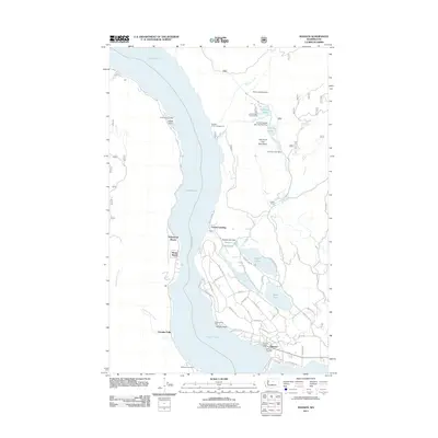
2011 Map of Manson
USGS Topo · Published 2011About this map
The eastern shore of Lake Chelan reveals a landscape defined by waterfront settlements and a sophisticated irrigation and water management system at the start of the 2010s. The community of Manson serves as the primary hub, where Manson Bay Park and the Manson Ferry Landing anchor the local economy to the water. Moving north along the lake, residential and recreational enclaves like Willow Point, Shrine Beach, and Hollywood Beach line the shore, while Greens Landing and Fields Point Landing mark historic transit points for lake travel.
Find a feature on this map
63 named features on this map. Tap any name to fly to it.
Don’t see what you’re looking for? This feature index may not catch every label — zoom into the map to look around manually.
Map Details
Editions of this 2011 Manson Map
This is the sole edition of this map. No revisions or reprints were ever made.
Other maps of this area

1899 · Methow
USGS Topo · 1:125,000

1901 · Chelan
USGS Topo · 1:125,000

1901 · Methow
USGS Topo · 1:125,000

1955 · Concrete
USGS Topo · 1:250,000

1957 · Wenatchee
USGS Topo · 1:250,000

1958 · Concrete
USGS Topo · 1:250,000

1962 · Concrete
USGS Topo · 1:250,000

1968 · Chelan
USGS Topo · 1:24,000

1968 · South Navarre Peak
USGS Topo · 1:24,000
1968 · Cooper Ridge
USGS Topo · 1:24,000