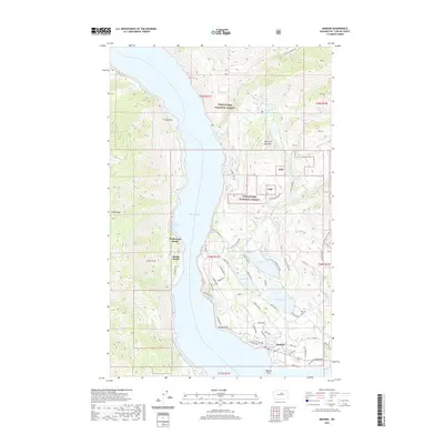
2020 Map of Manson
USGS Topo · Published 2020About this map
The eastern shores of Lake Chelan define this landscape, where the community of Manson sits at the foot of the Wenatchee National Forest. This 2020 survey reveals a complex irrigation and water management system in the high desert of Chelan County, evidenced by a series of significant inland water bodies including Wapato Lake, Roses Lake, and Dry Lake. These basins, along with Antilon Lake further north, represent a vital agricultural and recreational network surrounding the town.
Find a feature on this map
61 named features on this map. Tap any name to fly to it.
Don’t see what you’re looking for? This feature index may not catch every label — zoom into the map to look around manually.
Map Details
Editions of this 2020 Manson Map
This is the sole edition of this map. No revisions or reprints were ever made.
Other maps of this area

1899 · Methow
USGS Topo · 1:125,000

1901 · Chelan
USGS Topo · 1:125,000

1901 · Methow
USGS Topo · 1:125,000

1955 · Concrete
USGS Topo · 1:250,000

1957 · Wenatchee
USGS Topo · 1:250,000

1958 · Concrete
USGS Topo · 1:250,000

1962 · Concrete
USGS Topo · 1:250,000

1968 · Chelan
USGS Topo · 1:24,000

1968 · South Navarre Peak
USGS Topo · 1:24,000
1968 · Cooper Ridge
USGS Topo · 1:24,000