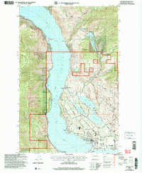
2004 Map of Manson
USGS Topo · Published 2008About this map
Lake Chelan dominates this 2004 revision of the landscape, where the deep waters divide the steep slopes of Wenatchee National Forest from the established orchard and residential lands around Manson. The eastern shore is defined by a cluster of smaller water bodies including Wapato Lake, Roses Lake, and Dry Lake, which anchor the agricultural and recreational development near Wapato Point. On the western side, the terrain rises sharply toward Slide Ridge, marked by the distinct Granite Slide and isolated points like Fields Point Landing. Local history and infrastructure are visible through the network of roads such as Wapato Lake Road and Manson Blvd, alongside community sites like the Cem and Old Mill Park. The map reveals the managed nature of the forest boundary, interspersed with private lands like Canyon Ranch and several designated boat landings.
Find a feature on this map
55 named features on this map. Tap any name to fly to it.
Don’t see what you’re looking for? This feature index may not catch every label — zoom into the map to look around manually.
Map Details
Editions of this 2004 Manson Map
This is the sole edition of this map. No revisions or reprints were ever made.
Other maps of this area

1899 · Methow
USGS Topo · 1:125,000

1901 · Chelan
USGS Topo · 1:125,000

1901 · Methow
USGS Topo · 1:125,000

1955 · Concrete
USGS Topo · 1:250,000

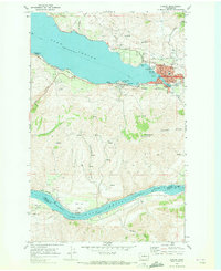
1957 · Wenatchee
USGS Topo · 1:250,000

1958 · Concrete
USGS Topo · 1:250,000

1962 · Concrete
USGS Topo · 1:250,000
1968 · Chelan
USGS Topo · 1:24,000
1968 · South Navarre Peak
USGS Topo · 1:24,000
1968 · Cooper Ridge
USGS Topo · 1:24,000