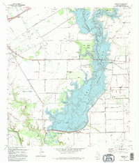
1995 Map of Manson
USGS Topo · Published 1995About this map
Lake Texana dominates this landscape, created by the Palmetto Bend Dam and stretching across the Navidad River valley. This 1990s record captures a coastal plain transitioning from traditional ranching and oil production to recreation and conservation. The reservoir is surrounded by public spaces like Lake Texana State Park and the Brackenridge Plantation Recreation Area, which preserve local history alongside modern campsites and boat ramps.
Find a feature on this map
27 named features on this map. Tap any name to fly to it.
Don’t see what you’re looking for? This feature index may not catch every label — zoom into the map to look around manually.
Map Details
Editions of this 1995 Manson Map
This is the sole edition of this map. No revisions or reprints were ever made.
Other maps of this area

1952 · Francitas NW
USGS Topo · 1:24,000

1952 · Manson
USGS Topo · 1:24,000

1952 · Edna
USGS Topo · 1:24,000

1952 · La Salle
USGS Topo · 1:24,000

1952 · La Ward
USGS Topo · 1:24,000

1952 · Lolita
USGS Topo · 1:24,000

1953 · Beeville
USGS Topo · 1:250,000

1953 · Seguin
USGS Topo · 1:250,000

1956 · Beeville
USGS Topo · 1:250,000

1958 · Seguin
USGS Topo · 1:250,000