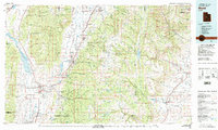
1981 Map of Manti
USGS Topo · Published 1981About this map
Manti-La Sal National Forest dominates the center of this 1981 survey, spanning the high elevations of the Wasatch Plateau. The map documents the distinct geography of Central Utah, where the San Pitch River valley provides the backbone for historical Mormon corridor settlements like Manti, Ephraim, and Spring City. These agricultural communities are connected by the Denver and Rio Grande Western railroad, which follows the contours of the valley floor. To the east, the landscape drops toward the Castle Valley, featuring the coal-mining and farming towns of Orangeville and Castle Dale. Water management is a primary theme of the era, visible in the network of high-country catchments such as Joes Valley Reservoir and Miller Flat Reservoir, which support the irrigation needs of the arid Sanpete and Emery county basins below.
Find a feature on this map
59 named features on this map. Tap any name to fly to it.
Don’t see what you’re looking for? This feature index may not catch every label — zoom into the map to look around manually.
Map Details
Editions of this 1981 Manti Map
2 editions found
Other maps of this area

1885 · San Rafael
USGS Topo · 1:250,000

1885 · Manti
USGS Topo · 1:250,000

1885 · Beaver
USGS Topo · 1:250,000

1885 · Sevier Desert
USGS Topo · 1:250,000

1885 · Fish Lake
USGS Topo · 1:250,000

1886 · Price River
USGS Topo · 1:250,000

1895 · Manti
USGS Topo · 1:250,000

1896 · Price River
USGS Topo · 1:250,000

1896 · Fish Lake
USGS Topo · 1:250,000

1914 · Castle Gate
USGS Topo · 1:62,500