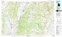
1981 Map of Manti
USGS Topo · Published 1981About this map
The San Pitch River flows through the central corridor of this 1981 survey, anchoring a string of agricultural settlements that includes Manti, Ephraim, and Spring City. This region reflects a complex landscape of water management and resource extraction at the edge of the Manti-La Sal National Forest. To the west, the San Pitch Mountains and Valley Mountains frame the valley, while the massive Wasatch Plateau dominates the eastern half of the sheet. Industrial activity is concentrated in the northeast corner near Hiawatha and the King Mine, where the Denver and Rio Grande Western railroad serves the coal-rich highlands. The map also captures significant irrigation infrastructure, from the large Joe's Valley Reservoir in the high plateaus to the smaller Gunnison Reservoir and numerous state wildlife management areas like Mayfield S W M A.
Find a feature on this map
70 named features on this map. Tap any name to fly to it.
Don’t see what you’re looking for? This feature index may not catch every label — zoom into the map to look around manually.
Map Details
Editions of this 1981 Manti Map
2 editions found
Other maps of this area

1885 · San Rafael
USGS Topo · 1:250,000

1885 · Manti
USGS Topo · 1:250,000

1885 · Beaver
USGS Topo · 1:250,000

1885 · Sevier Desert
USGS Topo · 1:250,000

1885 · Fish Lake
USGS Topo · 1:250,000

1886 · Price River
USGS Topo · 1:250,000

1895 · Manti
USGS Topo · 1:250,000

1896 · Price River
USGS Topo · 1:250,000

1896 · Fish Lake
USGS Topo · 1:250,000

1914 · Castle Gate
USGS Topo · 1:62,500