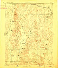
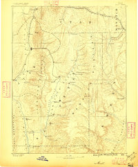
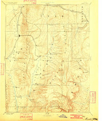
1885 Map of Manti
USGS Topo · Published 1910About this map
Settlements of the Sanpete and Juab valleys appear here in a broad overview of central Utah, based on work by the Powell Survey. The urban footprints of Nephi and Manti anchor the landscape, which is sharply divided by the San Pitch Mountains and the massive Wasatch Plateau. The map illustrates the region's transport reliance on the Denver & Rio Grande Western RR as it winds through the northern canyons near Thistle and Tucker, while the Utah Central RR serves the western corridor through Mona and Levan. This survey was conducted before the full industrialization of the coal fields in the east, yet it clearly identifies growing towns like Scofield and Huntington in the Castle Valley. The geography reveals a classic Great Basin settlement pattern, where towns like Ephraim and Mount Pleasant are situated specifically where mountain streams like Ephraim Creek and Pleasant Creek emerge onto the valley floor.
Find a feature on this map
63 named features on this map. Tap any name to fly to it.
Don’t see what you’re looking for? This feature index may not catch every label — zoom into the map to look around manually.
Map Details
Editions of this 1885 Manti Map
4 editions found
Other maps of this area

1885 · San Rafael
USGS Topo · 1:250,000

1885 · Salt Lake
USGS Topo · 1:250,000

1885 · Manti
USGS Topo · 1:250,000

1885 · Beaver
USGS Topo · 1:250,000

1885 · Sevier Desert
USGS Topo · 1:250,000

1885 · Fish Lake
USGS Topo · 1:250,000

1885 · Uinta
USGS Topo · 1:250,000

1885 · Tooele Valley
USGS Topo · 1:250,000

1886 · Price River
USGS Topo · 1:250,000

1895 · Manti
USGS Topo · 1:250,000