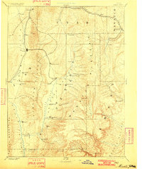
1885 Map of Manti
USGS Topo · Published 1901About this map
The San Pete Valley and Juab Valley serve as the primary corridors for settlement and transportation in this 1880s survey. Major agricultural and administrative hubs including Manti, Nephi, and Ephraim are depicted along the fertile drainages of the San Pete River and Salt Creek. The landscape is dominated by the high elevations of the Wasatch Mountains and the Wasatch Plateau, where the early industrial footprint of the Denver & Rio Grande Western RR penetrates the rugged interior near Pleasant Valley Junction and Scofield. To the west, the Utah Central RR skirts the base of the Gunnison Plateau, connecting northern settlements like Santaquin and Goshen to the southern valleys. These transportation networks illustrate the transition from isolated frontier outposts to an integrated regional economy driven by mining and mountain-pass commerce.
Find a feature on this map
57 named features on this map. Tap any name to fly to it.
Don’t see what you’re looking for? This feature index may not catch every label — zoom into the map to look around manually.
Map Details
Editions of this 1885 Manti Map
4 editions found
Other maps of this area

1885 · San Rafael
USGS Topo · 1:250,000

1885 · Salt Lake
USGS Topo · 1:250,000

1885 · Manti
USGS Topo · 1:250,000

1885 · Beaver
USGS Topo · 1:250,000

1885 · Sevier Desert
USGS Topo · 1:250,000

1885 · Fish Lake
USGS Topo · 1:250,000

1885 · Uinta
USGS Topo · 1:250,000

1885 · Tooele Valley
USGS Topo · 1:250,000

1886 · Price River
USGS Topo · 1:250,000

1895 · Manti
USGS Topo · 1:250,000