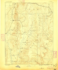
1885 Map of Manti
USGS Topo · Published 1896About this map
The San Pete River and Sevier River Valley form the agricultural and social backbone of this central Utah landscape during the late nineteenth century. Established Mormon settlements are densely clustered between the Gunnison Plateau and the Wasatch Plateau, where early town planning is evident in the grid layouts of Manti, Nephi, and Ephraim. The map records a critical moment in regional transportation, showing the Utah Central Railroad pushing south through the Juab Valley while the Denver & Rio Grande Western RR traverses the northern canyons near Thistle Creek. To the east, the geography shifts toward the coal-bearing regions of Pleasant Valley and the rising industrial presence at Scofield, marking the transition from the irrigated valley floors to the high-country resource economies that would define the area's growth.
Find a feature on this map
54 named features on this map. Tap any name to fly to it.
Don’t see what you’re looking for? This feature index may not catch every label — zoom into the map to look around manually.
Map Details
Editions of this 1885 Manti Map
4 editions found
Other maps of this area

1885 · San Rafael
USGS Topo · 1:250,000

1885 · Salt Lake
USGS Topo · 1:250,000

1885 · Manti
USGS Topo · 1:250,000

1885 · Beaver
USGS Topo · 1:250,000

1885 · Sevier Desert
USGS Topo · 1:250,000

1885 · Fish Lake
USGS Topo · 1:250,000

1885 · Uinta
USGS Topo · 1:250,000

1885 · Tooele Valley
USGS Topo · 1:250,000

1886 · Price River
USGS Topo · 1:250,000

1895 · Manti
USGS Topo · 1:250,000