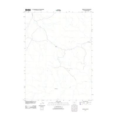
2012 Map of Manuel Gap
USGS Topo · Published 2012About this map
Adobe Town and its high desert surroundings are the focus of this 2012 survey in Sweetwater County. The map details the drainage patterns and intermittent flow of Sand Cr as it meanders through the arid basin. This region is characterized by significant topographic shifts, most notably at Manuel Gap, where the terrain creates a natural passage used by local travel routes. Bureau of Land Management infrastructure is present through BLM Road 4409 and BLM Road 4411, which provide the primary access through this sparsely populated territory. The map illustrates the specialized landscape of southwestern Wyoming, where wide-open spaces are punctuated by specific named landmarks and ephemeral watercourses rather than dense urban centers.
Find a feature on this map
5 named features on this map. Tap any name to fly to it.
Don’t see what you’re looking for? This feature index may not catch every label — zoom into the map to look around manually.
Map Details
Editions of this 2012 Manuel Gap Map
This is the sole edition of this map. No revisions or reprints were ever made.
Other maps of this area

1954 · Rock Springs
USGS Topo · 1:250,000

1958 · Rock Springs
USGS Topo · 1:250,000

1962 · Rock Springs
USGS Topo · 1:250,000

1970 · Cow Creek Reservoir
USGS Topo · 1:24,000

1970 · Prehistoric Rim
USGS Topo · 1:24,000
1970 · Kinney Spring
USGS Topo · 1:24,000

1970 · Manuel Gap
USGS Topo · 1:24,000
1970 · Barrel Springs SW
USGS Topo · 1:24,000
1970 · Monument Valley
USGS Topo · 1:24,000

1970 · Fort La Clede NE
USGS Topo · 1:24,000