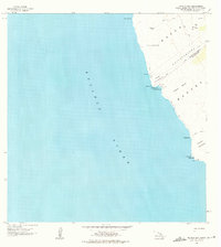
1962 Map of Manuka Bay
USGS Topo · Published 1975About this map
Kipuka Kaulanamauna and other isolated pockets of vegetation define this coastal portion of the Big Island, where historical evidence of native Hawaiian life meets mid-century military activity. Along the shore of the Pacific Ocean, several ruins and a heiau are recorded near Manuka Bay, marking the site of ancient cultural significance. Further south toward Kauna Pt, the map identifies a Coast Guard Reservation and a light, indicating the area's ongoing importance for maritime navigation.
Find a feature on this map
29 named features on this map. Tap any name to fly to it.
Don’t see what you’re looking for? This feature index may not catch every label — zoom into the map to look around manually.
Map Details
Editions of this 1962 Manuka Bay Map
2 editions found
Other maps of this area

1928 · Hoopuloa
USGS Topo · 1:62,500

1954 · Hawaii South
USGS Topo · 1:250,000

1959 · Hawaii South
USGS Topo · 1:250,000

1961 · Hawaii South
USGS Topo · 1:250,000

1962 · Hawaii South
USGS Topo · 1:250,000

1962 · Milolii
USGS Topo · 1:24,000
1962 · Manuka Bay
USGS Topo · 1:24,000

1962 · Pohue Bay
USGS Topo · 1:24,000

1962 · Papa
USGS Topo · 1:24,000

1975 · Hawaii
USGS Topo · 1:250,000