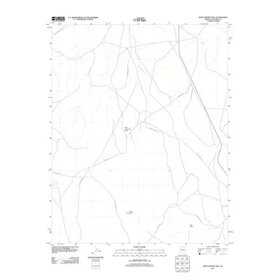
2011 Map of Many Ghosts Hill
USGS Topo · Published 2011About this map
Many Ghosts Hill rises above the high plateau country of Coconino County, anchoring a landscape defined by seasonal watercourses and remote access routes. This area is characterized by vast, open expanses like Low Valley and the distinctively named Wild Horse Trap Mesa, where the terrain and sparse water sources like Alkali Tank shaped the movements of both livestock and early travelers. The intermittent flow of Antelope Creek cuts through the territory, highlighting the importance of drainage patterns in this arid environment. Transportation across the region is facilitated by a network of unimproved tracks, including Forest Service Rd and Indian Rte 201, which serve as vital connectors in an otherwise sparsely populated ranching and grazing district. These features illustrate the enduring character of Arizona's upland ranching landscape into the early twenty-first century.
Find a feature on this map
7 named features on this map. Tap any name to fly to it.
Don’t see what you’re looking for? This feature index may not catch every label — zoom into the map to look around manually.
Map Details
Editions of this 2011 Many Ghosts Hill Map
This is the sole edition of this map. No revisions or reprints were ever made.
Other maps of this area

1886 · Echo Cliffs
USGS Topo · 1:250,000

1891 · Echo Cliffs
USGS Topo · 1:250,000

1954 · Leche-E Rock
USGS Topo · 1:62,500

1954 · Navajo Creek
USGS Topo · 1:62,500

1956 · Marble Canyon
USGS Topo · 1:250,000

1959 · Marble Canyon
USGS Topo · 1:250,000

1961 · Marble Canyon
USGS Topo · 1:250,000
1981 · Horsethief Mesa
USGS Topo · 1:24,000
1982 · Arrowhead Mesa
USGS Topo · 1:24,000
1982 · Many Ghosts Hill
USGS Topo · 1:24,000