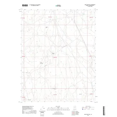
2018 Map of Many Ghosts Hill
USGS Topo · Published 2018About this map
Many Ghosts Hill rises from a landscape of high desert mesas and deep drainage systems in northern Arizona, as documented by this Bureau of Land Management and USGS study. The area is defined by sharp topographic transitions, from the high plateau of Wild Horse Trap Mesa to the drainage of Antelope Canyon. Evidence of land management and transportation is visible through the winding path of Indian Rte 201, which traverses the central portion of the quadrangle. Other distinctive landforms include the Circular White Ridge and the Mormon Ridges to the southwest. Water resources are sparse, indicated by the isolated Alkali Tank and the seasonal Antelope Cr flow. This survey captures a moment in the modern era of Coconino County, where the topography dictates movement through the Low Valley and across the segmented township and range lines.
Find a feature on this map
18 named features on this map. Tap any name to fly to it.
Don’t see what you’re looking for? This feature index may not catch every label — zoom into the map to look around manually.
Map Details
Editions of this 2018 Many Ghosts Hill Map
This is the sole edition of this map. No revisions or reprints were ever made.
Other maps of this area

1886 · Echo Cliffs
USGS Topo · 1:250,000

1891 · Echo Cliffs
USGS Topo · 1:250,000

1954 · Leche-E Rock
USGS Topo · 1:62,500

1954 · Navajo Creek
USGS Topo · 1:62,500

1956 · Marble Canyon
USGS Topo · 1:250,000

1959 · Marble Canyon
USGS Topo · 1:250,000

1961 · Marble Canyon
USGS Topo · 1:250,000
1981 · Horsethief Mesa
USGS Topo · 1:24,000
1982 · Arrowhead Mesa
USGS Topo · 1:24,000
1982 · Many Ghosts Hill
USGS Topo · 1:24,000