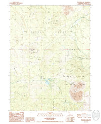
1985 Map of Manzanita Lake
USGS Topo · Published 1985About this map
Lassen Volcanic National Park dominates the southern landscape of this 1980s provisional survey, revealing a complex geological terrain shaped by recent volcanic activity. The northwest entrance of the park is anchored by Manzanita Lake, where the Visitor Center, an Entrance Station, and the Manzanita Lake Campground suggest the area's development for tourism. To the east, the dramatic Chaos Crags and Chaos Crater overlook the massive debris field known as Chaos Jumbles, providing a clear record of the region's massive rockfall history. Beyond the park boundary, the landscape transitions into the Lassen National Forest, featuring topographical landmarks such as Table Mountain and the broad Bunchgrass Valley. Historical routes are noted through Nobles Pass, while local recreation is marked by sites like Eskimo Hill and various camps along Lost Creek.
Find a feature on this map
36 named features on this map. Tap any name to fly to it.
Don’t see what you’re looking for? This feature index may not catch every label — zoom into the map to look around manually.
Map Details
Editions of this 1985 Manzanita Lake Map
2 editions found
Other maps of this area

1886 · Lassen Peak
USGS Topo · 1:250,000

1892 · Lassen Peak
USGS Topo · 1:250,000

1894 · Lassen Peak
USGS Topo · 1:250,000

1935 · Burney
USGS Topo · 1:96,000

1935 · Paynes Creek
USGS Topo · 1:96,000

1939 · Burney
USGS Topo · 1:125,000

1939 · Halls Flat
USGS Topo · 1:125,000

1941 · Mineral
USGS Topo · 1:125,000

1955 · Westwood
USGS Topo · 1:250,000

1956 · Lassen Peak
USGS Topo · 1:62,500