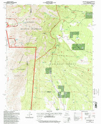
1995 Map of Manzano Peak
USGS Topo · Published 1998About this map
Manzano Peak dominates this high-altitude landscape where the Manzano Mountains meet several Spanish land grants, including the Tome Grant, Belen Grant, and Casa Colorada Grant. The terrain is characterized by its reliance on water sources, documented through a dense network of springs and wells such as Rattlesnake Spring, Ojo Barreras, and the Priest Canyon Well. Human activity is marked by the industrial presence of Kayser Mill and infrastructure like the First Standard Parallel North.
Find a feature on this map
64 named features on this map. Tap any name to fly to it.
Don’t see what you’re looking for? This feature index may not catch every label — zoom into the map to look around manually.
Map Details
Editions of this 1995 Manzano Peak Map
This is the sole edition of this map. No revisions or reprints were ever made.
Other maps of this area

1916 · La Joya
USGS Topo · 1:125,000

1917 · Estancia
USGS Topo · 1:125,000

1952 · Tome SE
USGS Topo · 1:24,000

1952 · Tome NE
USGS Topo · 1:24,000

1952 · Becker
USGS Topo · 1:24,000

1954 · Capilla Peak
USGS Topo · 1:24,000

1954 · Torreon
USGS Topo · 1:24,000

1954 · Torreon
USGS Topo · 1:62,500

1954 · Socorro
USGS Topo · 1:250,000

1958 · Socorro
USGS Topo · 1:250,000