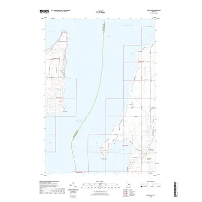
2019 Map of Mapleton
USGS Topo · Published 2019About this map
Old Mission Peninsula divides the waters of Lake Michigan into the primary arms of Grand Traverse Bay, anchoring a landscape defined by its distinctive shoreline and agricultural layout. The settlement of Mapleton serves as a central hub on the peninsula, surrounded by coastal features such as Bowers Harbor and several prominent landforms including Tucker Point and Neah-Ta-Wanta Point. To the west across the West Arm Grand Traverse Bay, the coastline of Leelanau County is visible near Suttons Bay, where Stony Point and Lee Point extend into the water. For local historians and genealogists, the map identifies key community sites such as Ogdensburg Cem and Bowers Harbor Cem, alongside a dense network of local roads like Center Rd and Peninsula Dr that reflect the area's development and enduring connection to its maritime environment.
Find a feature on this map
61 named features on this map. Tap any name to fly to it.
Don’t see what you’re looking for? This feature index may not catch every label — zoom into the map to look around manually.
Map Details
Editions of this 2019 Mapleton Map
This is the sole edition of this map. No revisions or reprints were ever made.
Other maps of this area

1954 · Central Lake
USGS Topo · 1:62,500

1954 · Traverse City
USGS Topo · 1:250,000

1955 · Cheboygan
USGS Topo · 1:250,000

1957 · Traverse City
USGS Topo · 1:62,500

1957 · Northport
USGS Topo · 1:62,500

1957 · Elk Rapids
USGS Topo · 1:62,500

1958 · Cheboygan
USGS Topo · 1:250,000

1958 · Traverse City
USGS Topo · 1:250,000

1983 · Omena
USGS Topo · 1:24,000

1983 · Traverse City SE
USGS Topo · 1:25,000
Featured Places
- Peninsula Township, MI
- Bingham Township, MI
- Mapleton, Peninsula Township
- Neahtawanta, Peninsula Township
- Suttons Bay Township, MI