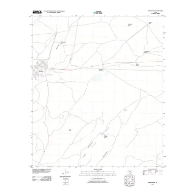
2010 Map of Marathon
USGS Topo · Published 2010About this map
Marathon serves as the primary hub of this West Texas landscape, where the town’s grid sits at the intersection of critical regional routes like Ave D and Airport Rd. The map illustrates a ranching and homesteading pattern defined by widely dispersed family sites and legacy locations, such as the Old Beekley Place, Causey Ranch, and Louis Granger Place. This 2010 survey highlights how human activity in the region is tethered to topographic features and seasonal water sources.
Find a feature on this map
19 named features on this map. Tap any name to fly to it.
Don’t see what you’re looking for? This feature index may not catch every label — zoom into the map to look around manually.
Map Details
Editions of this 2010 Marathon Map
This is the sole edition of this map. No revisions or reprints were ever made.
Other maps of this area

1920 · Monument Spring
USGS Topo · 1:62,500

1920 · Marathon
USGS Topo · 1:62,500

1921 · Monument Spring
USGS Topo · 1:62,500

1921 · Marathon
USGS Topo · 1:62,500

1923 · Hess Canyon
USGS Topo · 1:62,500

1923 · Altuda
USGS Topo · 1:62,500

1954 · Fort Stockton
USGS Topo · 1:250,000

1958 · Fort Stockton
USGS Topo · 1:250,000
1967 · Horse Mountain
USGS Topo · 1:24,000

1973 · Fort Stockton
USGS Topo · 1:250,000