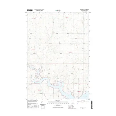
2015 Map of Marathon SW
USGS Topo · Published 2015About this map
Big Eau Pleine Reservoir dominates the southern portion of this landscape, its irregular shoreline forming deep coves fed by the Big Eau Pleine River. This Marathon County terrain reflects a late 20th-century rural layout defined by a rigorous grid of section-line roads, many of which bear local family or nature-based names like Still Hill Rd, Sugar Bush Rd, and Schnelle Rd. The land is dissected by multiple watercourses, including Rocky Run and Burns Cr, which carve through the elevations. Aside from the sprawling reservoir, notable landmarks are sparse, with Maguire Field serving as a localized point of interest in an area otherwise characterized by timber and agricultural tracts. The intricate web of local connectors like Range Line Rd and Fairview Rd illustrates the persistent structure of Wisconsin's township-and-range system.
Find a feature on this map
59 named features on this map. Tap any name to fly to it.
Don’t see what you’re looking for? This feature index may not catch every label — zoom into the map to look around manually.
Map Details
Editions of this 2015 Marathon SW Map
This is the sole edition of this map. No revisions or reprints were ever made.
Other maps of this area

1902 · Marathon
USGS Topo · 1:125,000

1953 · Marathon
USGS Topo · 1:48,000

1953 · Stratford
USGS Topo · 1:48,000

1953 · Eau Claire
USGS Topo · 1:250,000

1954 · Marshfield
USGS Topo · 1:62,500

1955 · Green Bay
USGS Topo · 1:250,000

1956 · Milladore
USGS Topo · 1:48,000

1958 · Eau Claire
USGS Topo · 1:250,000

1963 · Marathon
USGS Topo · 1:62,500

1963 · Stratford
USGS Topo · 1:62,500