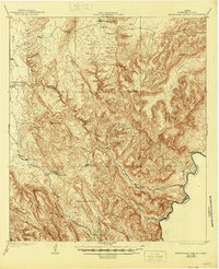
1919 Map of Maravillas Canyon
USGS Topo · Published 1945About this map
Stillwell Ranch and Pettit Ranch anchor this landscape of the Texas Big Bend, surveyed by R.W. Berry and H.B. Ingersoll during the late 1910s. The terrain is dominated by the deep incisions of Maravillas Canyon and Reagan Canyon, which feed toward the Rio Grande as it forms the international border with Mexico. The importance of water in this arid environment is evidenced by numerous named catchment features like Blue Cave Tank, Rockhouse Tank, and Hole in the ground Tank. Elevated landmarks including Stillwell Mtn and the Dove Mountain Range define the horizon, while Black Gap provides a notable natural passage through the peaks. This survey captures the remote ranching infrastructure of Brewster County before the era of modern development, showing the winding trail systems that connected these isolated outposts.
Find a feature on this map
26 named features on this map. Tap any name to fly to it.
Don’t see what you’re looking for? This feature index may not catch every label — zoom into the map to look around manually.
Map Details
Editions of this 1919 Maravillas Canyon Map
2 editions found

Other maps of this area

1903 · Chisos Mountains
USGS Topo · 1:125,000

1905 · Chisos Mountains
USGS Topo · 1:125,000

1917 · Bone Spring
USGS Topo · 1:62,500

1917 · Hood Spring
USGS Topo · 1:62,500

1918 · Reagan Canyon
USGS Topo · 1:62,500

1918 · Bone Spring
USGS Topo · 1:125,000

1918 · Hood Spring
USGS Topo · 1:62,500

1918 · Dove Mountain
USGS Topo · 1:62,500

1918 · Bone Spring
USGS Topo · 1:62,500

1918 · Bullis Gap
USGS Topo · 1:62,500