
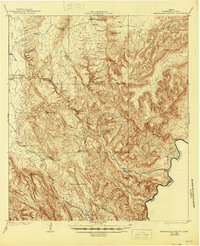
1919 Map of Maravillas Canyon
USGS Topo · Published 1919About this map
Maravillas Canyon and its complex network of secondary drainages like Big Canyon and Dog Canyon define this high-desert landscape in Brewster County. In 1917, as surveyors from the U.S. Geological Survey and the War Department mapped this border region, human presence was tied closely to water sources. Named ranch sites such as Stillwell Ranch, Pettit Ranch, and Rockhouse Ranch are positioned near key landmarks like Waterholes or the Rio Grande. This period reflects the early twentieth-century ranching era before the establishment of modern protected lands, where life revolved around precarious water features like Hole in the ground Tank and Bee Cave Tank. The southern border follows the winding path of the Rio Grande, marking the international boundary between the United States and Mexico near the state of Coahuila. High points such as Cupola Mtn and Stairway Mtn provide significant vertical relief in this desert environment.
Find a feature on this map
24 named features on this map. Tap any name to fly to it.
Don’t see what you’re looking for? This feature index may not catch every label — zoom into the map to look around manually.
Map Details
Editions of this 1919 Maravillas Canyon Map
2 editions found
Other maps of this area

1903 · Chisos Mountains
USGS Topo · 1:125,000

1905 · Chisos Mountains
USGS Topo · 1:125,000

1917 · Bone Spring
USGS Topo · 1:62,500

1917 · Hood Spring
USGS Topo · 1:62,500

1918 · Reagan Canyon
USGS Topo · 1:62,500

1918 · Bone Spring
USGS Topo · 1:125,000

1918 · Hood Spring
USGS Topo · 1:62,500

1918 · Dove Mountain
USGS Topo · 1:62,500

1918 · Bone Spring
USGS Topo · 1:62,500

1918 · Bullis Gap
USGS Topo · 1:62,500