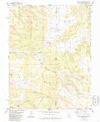
1985 Map of Marble Canyon
USGS Topo · Published 1986About this map
Picture Gallery Ranch and Spring Creek Ranch sit within a high-elevation landscape defined by the drainage systems of the Book Cliffs region. This mid-1980s topography documents the intersection of remote ranching outposts and aviation infrastructure, with several Landing Strips and a primary Landing Strip supporting access to these isolated properties. The terrain is marked by deep incisions like Marble Canyon and Star Canyon, which carry seasonal runoff toward the state line. In the southern portion of the map, Renegade Creek and Cow Creek wind through the complex topography near Red Gap. The cartography also captures the boundary where Grand County and Mesa County meet the Utah-Colorado border, illustrating the transition from the high flats of Fish Park to the sloping benches of Piñon Mesa.
Find a feature on this map
27 named features on this map. Tap any name to fly to it.
Don’t see what you’re looking for? This feature index may not catch every label — zoom into the map to look around manually.
Map Details
Editions of this 1985 Marble Canyon Map
This is the sole edition of this map. No revisions or reprints were ever made.
Other maps of this area

1885 · East Tavaputs
USGS Topo · 1:250,000

1885 · La Sal
USGS Topo · 1:250,000

1954 · Westwater 4 SW
USGS Topo · 1:24,000

1954 · Mt. Waas 1 SW
USGS Topo · 1:24,000

1954 · Mt. Waas 1 NE
USGS Topo · 1:24,000

1954 · Mt. Waas 1 NW
USGS Topo · 1:24,000

1954 · Mt. Waas 1 SE
USGS Topo · 1:24,000

1954 · Coates Creek
USGS Topo · 1:62,500

1956 · Westwater 4 SE
USGS Topo · 1:24,000

1956 · Moab
USGS Topo · 1:250,000