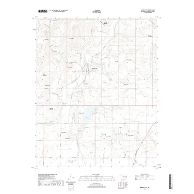
2018 Map of Marble City
USGS Topo · Published 2018About this map
Marble City sits at the heart of this landscape, positioned where the high ridges of the Brushy Mountains meet the waters of Sallisaw Creek. The area is defined by a series of prominent peaks and hollows, including Quarry Mtn, Andes Mtn, and Schoolhouse Mtn, which frame the local topography. To the south of the settlement, the Brushy Creek Reservoir collects the flow from Creek Run and Brushy Cr. This 2018 survey reveals a terrain deeply connected to its local heritage, notably through the presence of the Dwight Mission and the Dwight Cem nearby. Genealogists will find several burial grounds across the hills, from Marble City Cem to the more secluded McCoy Cem located near the southern boundary along the Hog Cr drainage.
Find a feature on this map
88 named features on this map. Tap any name to fly to it.
Don’t see what you’re looking for? This feature index may not catch every label — zoom into the map to look around manually.
Map Details
Editions of this 2018 Marble City Map
This is the sole edition of this map. No revisions or reprints were ever made.
Other maps of this area

1898 · Tahlequah
USGS Topo · 1:125,000

1900 · Sallisaw
USGS Topo · 1:125,000

1901 · Tahlequah
USGS Topo · 1:125,000

1905 · Tahlequah
USGS Topo · 1:125,000

1911 · Sallisaw
USGS Topo · 1:125,000

1946 · Fort Smith
USGS Topo · 1:250,000

1965 · Fort Smith
USGS Topo · 1:250,000

1966 · Gans
USGS Topo · 1:24,000

1967 · Fort Smith
USGS Topo · 1:250,000
1967 · Sallisaw
USGS Topo · 1:24,000