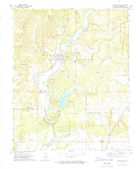
1972 Map of Marble City
USGS Topo · Published 1974About this map
Marble City serves as the focal point for this early 1970s survey of Sequoyah County, where the industrial presence of Quarries and a Mine at Quarry Mountain contrasts with the spiritual and educational history of the Dwight Mission. The Kansas City Southern railroad corridor parallels Sallisaw Creek, linking the town to nearby M C K E Y and the sprawling residential area of Prices Chapel. Local heritage is preserved in several small burial grounds, including Marble City Cem, Dwight Cem, and McCoy Cem. The landscape is defined by its water and recreation, featuring the Brushy Creek Reservoir and the Sallisaw State Recreation Area, which provides a counterpoint to the family-named heights of Leathers Mountain and Hastings Mountain. Numerous Gravel Pits and a prominent Water Tank underscore the utility-focused development of the era.
Find a feature on this map
45 named features on this map. Tap any name to fly to it.
Don’t see what you’re looking for? This feature index may not catch every label — zoom into the map to look around manually.
Map Details
Editions of this 1972 Marble City Map
This is the sole edition of this map. No revisions or reprints were ever made.
Other maps of this area

1898 · Tahlequah
USGS Topo · 1:125,000

1900 · Sallisaw
USGS Topo · 1:125,000

1901 · Tahlequah
USGS Topo · 1:125,000

1905 · Tahlequah
USGS Topo · 1:125,000

1911 · Sallisaw
USGS Topo · 1:125,000

1946 · Fort Smith
USGS Topo · 1:250,000

1965 · Fort Smith
USGS Topo · 1:250,000

1966 · Gans
USGS Topo · 1:24,000

1967 · Fort Smith
USGS Topo · 1:250,000
1967 · Sallisaw
USGS Topo · 1:24,000