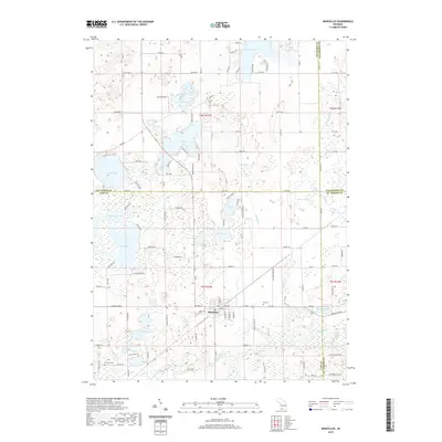
2019 Map of Marcellus
USGS Topo · Published 2019About this map
Marcellus serves as the central hub of this southwestern Michigan landscape, situated where the Rocky River begins its winding path through a complex network of glacial kettle lakes. The map documents a territory defined by its water, from the large expanse of Gravel Lake in the west to the cluster of smaller basins including Cedar Lake, Little Cedar Lake, and Hemlock Lake. These water bodies are connected by a grid of rural roads and county lines, including the notable Four County Drain that marks the convergence of Van Buren, Kalamazoo, Cass, and St. Joseph counties. Local history and genealogy interests are anchored by sites such as the Huyck Graves near the shores of Huyck Lake and the Bly Cem located east of the main village. The transition from agricultural land to lakeside residential areas is visible along routes like Shorelane Dr and Co Rd 652, reflecting the area's long-standing character as a recreational and farming community.
Find a feature on this map
119 named features on this map. Tap any name to fly to it.
Don’t see what you’re looking for? This feature index may not catch every label — zoom into the map to look around manually.
Map Details
Editions of this 2019 Marcellus Map
This is the sole edition of this map. No revisions or reprints were ever made.
Other maps of this area

1914 · Three Rivers
USGS Topo · 1:62,500

1916 · Three Rivers
USGS Topo · 1:62,500

1922 · Schoolcraft
USGS Topo · 1:62,500

1943 · Three Rivers
USGS Topo · 1:62,500

1943 · Schoolcraft
USGS Topo · 1:62,500

1944 · Marcellus
USGS Topo · 1:62,500

1946 · Marcellus
USGS Topo · 1:62,500

1948 · Vandalia
USGS Topo · 1:62,500

1949 · Vandalia
USGS Topo · 1:62,500

1953 · Fort Wayne
USGS Topo · 1:250,000
Featured Places
- Marcellus, MI
- Marcellus Township, MI
- Prairie Ronde Township, MI
- Porter Township, MI
- Flowerfield Township, MI