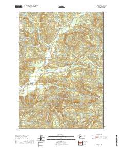
2020 Map of Marcola
USGS Topo · Published 2020About this map
Mohawk Valley and its surrounding highlands define this region northeast of Springfield, where the Mohawk River meanders between the Coburg Hills and Bunker Hill. The landscape is a network of small settlements and historical markers, including the village of Mabel and the nearby Wendling. Genealogists will find significant detail in the multiple burial sites documented here, such as the Marcola Cem, Mabel Cem, and Upper Mabel Cem.
Find a feature on this map
81 named features on this map. Tap any name to fly to it.
Don’t see what you’re looking for? This feature index may not catch every label — zoom into the map to look around manually.
Map Details
Editions of this 2020 Marcola Map
This is the sole edition of this map. No revisions or reprints were ever made.
Other maps of this area

1921 · Brownsville
USGS Topo · 1:62,500

1950 · Marcola
USGS Topo · 1:62,500

1950 · Brownsville
USGS Topo · 1:62,500

1951 · Sweet Home
USGS Topo · 1:62,500

1951 · Leaburg
USGS Topo · 1:62,500

1952 · Brownsville
USGS Topo · 1:62,500

1952 · Marcola
USGS Topo · 1:62,500

1953 · Salem
USGS Topo · 1:250,000

1954 · Salem
USGS Topo · 1:250,000

1960 · Salem
USGS Topo · 1:250,000