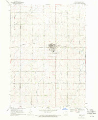
1969 Map of Marcus
USGS Topo · Published 1971About this map
Marcus serves as the central hub of this Northwest Iowa landscape, positioned at the intersection of local township life and the Illinois Central railroad. The town's layout reflects a classic Midwestern agricultural grid, supported by infrastructure like the Sewage Disposal plant and a nearby Landing Strip. Social and spiritual life is anchored by the Holy Name Cem and Marcus-Amherst Cem, which sit at the town's southern edge, while the Marcus Community Golf Club indicates the development of local recreation by the late 1960s.
Find a feature on this map
17 named features on this map. Tap any name to fly to it.
Don’t see what you’re looking for? This feature index may not catch every label — zoom into the map to look around manually.
Map Details
Editions of this 1969 Marcus Map
This is the sole edition of this map. No revisions or reprints were ever made.
Other maps of this area

1954 · Fort Dodge
USGS Topo · 1:250,000

1957 · Fort Dodge
USGS Topo · 1:250,000

1958 · Fort Dodge
USGS Topo · 1:250,000

1969 · Cleghorn
USGS Topo · 1:24,000

1969 · Fielding
USGS Topo · 1:24,000
1969 · Granville West
USGS Topo · 1:24,000
1969 · Granville East
USGS Topo · 1:24,000
1969 · Remsen
USGS Topo · 1:24,000
1969 · Kingsley NW
USGS Topo · 1:24,000
1969 · Quimby
USGS Topo · 1:24,000