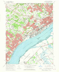
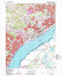
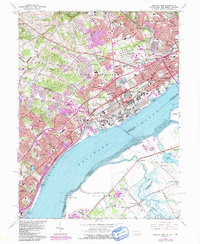
1967 Map of Marcus Hook
USGS Topo · Published 1970About this map
Industrial development and dense suburban expansion define the riverfront corridor between southeastern Pennsylvania and northern Delaware in the late 1960s. The Delaware River serves as the primary artery for the region, bordered by extensive infrastructure including massive Tank Farm clusters, Industrial Waste Ponds, and a sprawling Sewage Disposal plant. The landscape is deeply etched by the transportation networks of the Penn Central and Baltimore and Ohio railroads, which facilitated the growth of historic communities like Marcus Hook and Trainer.
Find a feature on this map
111 named features on this map. Tap any name to fly to it.
Don’t see what you’re looking for? This feature index may not catch every label — zoom into the map to look around manually.
Map Details
Editions of this 1967 Marcus Hook Map
3 editions found
Other maps of this area

1890 · Salem
USGS Topo · 1:62,500

1894 · Chester
USGS Topo · 1:62,500

1896 · Chester
USGS Topo · 1:62,500

1898 · Salem
USGS Topo · 1:62,500

1898 · Chester
USGS Topo · 1:62,500

1901 · Camden
USGS Topo · 1:125,000

1901 · West Chester
USGS Topo · 1:62,500

1904 · West Chester
USGS Topo · 1:62,500

1904 · Wilmington
USGS Topo · 1:62,500

1906 · Wilmington
USGS Topo · 1:62,500