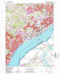
1967 Map of Marcus Hook
USGS Topo · Published 1987About this map
Marcus Hook and the industrial corridor along the Delaware River define this mid-century portrait of the Pennsylvania, Delaware, and New Jersey borderlands. The landscape transitions from the dense urban and shipping infrastructure of Trainer and Linwood to the planned communities of Arden, Ardentown, and Ardencroft. Extensive rail networks including the Baltimore and Ohio and Conrail serve the riverfront refineries and industrial sites, while the interior reveals older institutional landmarks such as the Caleb Pusey Historic Site and Our Lady of Angels College. Across the water in New Jersey, the terrain remains largely agricultural and marshy around Nortonville and Oldmans Creek, providing a sharp contrast to the manufacturing hub of Upper Chichester and Chester.
Find a feature on this map
104 named features on this map. Tap any name to fly to it.
Don’t see what you’re looking for? This feature index may not catch every label — zoom into the map to look around manually.
Map Details
Editions of this 1967 Marcus Hook Map
3 editions found
Other maps of this area

1890 · Salem
USGS Topo · 1:62,500

1894 · Chester
USGS Topo · 1:62,500

1896 · Chester
USGS Topo · 1:62,500

1898 · Salem
USGS Topo · 1:62,500

1898 · Chester
USGS Topo · 1:62,500

1901 · Camden
USGS Topo · 1:125,000

1901 · West Chester
USGS Topo · 1:62,500

1904 · West Chester
USGS Topo · 1:62,500

1904 · Wilmington
USGS Topo · 1:62,500

1906 · Wilmington
USGS Topo · 1:62,500