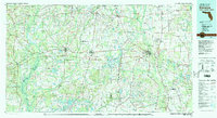
1979 Map of Marianna
USGS Topo · Published 1980About this map
The Chipola River and the Choctawhatchee River define the hydraulic character of this panhandle landscape, which straddles the borders of Florida, Alabama, and Georgia. Significant regional hubs like Marianna, Chipley, and Bonifay serve as anchors along the primary transit corridors. The transport network is heavily influenced by the Louisville and Nashville and the Atlanta and St Andrews Bay railroads, which facilitated the movement of goods and people across the tri-state area. Local recreation and natural heritage are highlighted by Florida Caverns State Park and the extensive waters of Merritts Mill Pond. The mapping reveals a transition from these established town centers to the smaller, more localized settlements of Graceville, Cottondale, and Greenwood. Aviation history is also present through the Marianna Municipal Airport and several abandoned auxiliary fields, reflecting the area's mid-century strategic importance.
Find a feature on this map
122 named features on this map. Tap any name to fly to it.
Don’t see what you’re looking for? This feature index may not catch every label — zoom into the map to look around manually.
Map Details
Editions of this 1979 Marianna Map
2 editions found
Other maps of this area

1935 · De Funiak Springs
USGS Topo · 1:48,000

1936 · Point Washington
USGS Topo · 1:48,000

1938 · De Funiak Springs
USGS Topo · 1:62,500

1939 · Point Washington
USGS Topo · 1:62,500

1942 · Enterprise
USGS Topo · 1:125,000

1944 · Clarksville
USGS Topo · 1:31,680

1944 · Crystal Lake
USGS Topo · 1:24,000

1944 · Bruce
USGS Topo · 1:24,000

1944 · Bennett
USGS Topo · 1:24,000

1945 · Juniper Creek
USGS Topo · 1:31,680