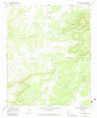
1967 Map of Mariano Springs
USGS Topo · Published 1984About this map
Mariano Springs serves as a focal point for this arid high-desert landscape in Catron County, where water management is the primary marker of human activity and survival. The map reveals an intricate network of tanks, wells, and springs, such as Stevens Tank, Gaines Well, and Cottonwood Spring, which supported the livestock and ranching efforts of the mid-20th century. Terrain features like the massive Mariano Mesa and the expansive Marshall Flat dominate the topography, while numerous ruins indicate earlier habitation or agricultural structures that had already fallen into disuse by the time of the 1966 aerial survey. Transport is limited to State Route 117, which cuts through the canyon systems like Dudley Canyon and across Sonoreno Draw. The distribution of family-named water sources, including Crossman Well and Tarpley Well, provides a clear view of the land-use patterns in this sparsely populated region of New Mexico.
Find a feature on this map
29 named features on this map. Tap any name to fly to it.
Don’t see what you’re looking for? This feature index may not catch every label — zoom into the map to look around manually.
Map Details
Editions of this 1967 Mariano Springs Map
2 editions found
Other maps of this area

1954 · Saint Johns
USGS Topo · 1:250,000

1957 · Saint Johns
USGS Topo · 1:250,000

1958 · Saint Johns
USGS Topo · 1:250,000

1962 · Saint Johns
USGS Topo · 1:250,000

1967 · Omega
USGS Topo · 1:24,000

1967 · Mariano Springs
USGS Topo · 1:24,000

1967 · Adams Diggings
USGS Topo · 1:24,000

1967 · Veteado Mountain
USGS Topo · 1:24,000

1967 · Quemado
USGS Topo · 1:24,000
1967 · Techado
USGS Topo · 1:24,000