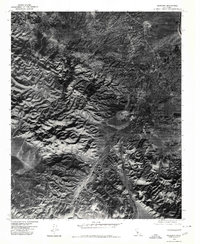
1976 Map of Maricopa
USGS Topo · Published 1980About this map
Maricopa sits at the eastern base of the Temblor Range in this mid-1970s orthophotographic study. This map provides a clear aerial perspective of the landscape transition where the rugged mountain slopes meet the flatter San Joaquin Valley floor. Visible terrain features include the prominent Signal Hill and the drainage patterns of Devils Gulch as they descend toward the settlement. The orthophoto format reveals the precise density of development and the grid of Maricopa during this era, showing the relationship between human habitation and the arid geological formations of the Temblor Range.
Find a feature on this map
4 named features on this map. Tap any name to fly to it.
Don’t see what you’re looking for? This feature index may not catch every label — zoom into the map to look around manually.
Map Details
Editions of this 1976 Maricopa Map
This is the sole edition of this map. No revisions or reprints were ever made.
Other maps of this area

1902 · Santa Ynez
USGS Topo · 1:125,000

1903 · Mt. Pinos
USGS Topo · 1:125,000

1905 · Santa Ynez
USGS Topo · 1:125,000

1910 · Buena Vista Lake
USGS Topo · 1:125,000

1912 · McKittrick
USGS Topo · 1:125,000

1912 · Buena Vista Lake
USGS Topo · 1:125,000

1929 · Mouth of Kern
USGS Topo · 1:31,680

1931 · Pentland Junction
USGS Topo · 1:31,680

1932 · Mouth of Kern
USGS Topo · 1:31,680

1934 · Pentland
USGS Topo · 1:31,680