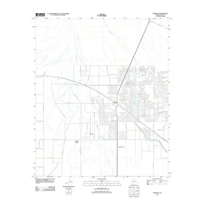
2011 Map of Maricopa
USGS Topo · Published 2011About this map
Maricopa and the neighboring Ak-Chin Village are the primary focus of this desert landscape, where suburban residential grids meet the natural drainages of the Sonora. The map documents a significant period of expansion, showing the intricate street layouts of modern subdivisions such as those branching off W Smith Enke Rd and W Edison Rd. To the south, the Ak Chin community is defined by larger agricultural or industrial plots and the prominent Harrah's Phoenix-Ak-Chin Casino Resort. The terrain is shaped by the ephemeral paths of Santa Rosa Wash and Vekol Wash, which meander through the developing town and more open desert areas. Aviation infrastructure is noted with the Hine Airstrip located east of the main residential core, while the northern reaches transition toward Casa Blanca Rd.
Find a feature on this map
61 named features on this map. Tap any name to fly to it.
Don’t see what you’re looking for? This feature index may not catch every label — zoom into the map to look around manually.
Map Details
Editions of this 2011 Maricopa Map
This is the sole edition of this map. No revisions or reprints were ever made.
Other maps of this area

1913 · Maricopa
USGS Topo · 1:62,500

1914 · Gila Butte
USGS Topo · 1:62,500

1915 · Maricopa
USGS Topo · 1:62,500

1917 · Gila Butte
USGS Topo · 1:62,500

1922 · Casa Grande
USGS Topo · 1:62,500

1924 · Casa Grande
USGS Topo · 1:62,500

1946 · Antelope Peak
USGS Topo · 1:62,500

1948 · Antelope Peak
USGS Topo · 1:62,500

1952 · Maricopa
USGS Topo · 1:24,000

1952 · Sacaton Butte
USGS Topo · 1:24,000