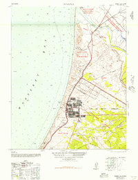
1948 Map of Marina
USGS Topo · Published 1948About this map
Fort Ord Military Reservation dominates this coastal landscape, reflecting the significant military presence in the post-war Monterey Bay area. The extensive grid of the Main Garrison and the residential clusters of Fort Ord Village sit adjacent to the growing town of Marina. This 1948 military edition, reprinted for civil use, reveals the intersection of defense infrastructure and regional commerce, featuring the Pacific Coast Aggregates Co Plant No 10 and the Southern Pacific railroad line snaking through the dunes.
Find a feature on this map
31 named features on this map. Tap any name to fly to it.
Don’t see what you’re looking for? This feature index may not catch every label — zoom into the map to look around manually.
Map Details
Editions of this 1948 Marina Map
This is the sole edition of this map. No revisions or reprints were ever made.
Other maps of this area

1910 · Salinas
USGS Topo · 1:31,680

1912 · Salinas
USGS Topo · 1:62,500

1912 · Capitola
USGS Topo · 1:62,500

1913 · Monterey
USGS Topo · 1:62,500

1914 · Capitola
USGS Topo · 1:62,500

1915 · San Juan Bautista
USGS Topo · 1:48,000

1917 · San Juan Bautista
USGS Topo · 1:62,500

1939 · San Juan Bautista
USGS Topo · 1:62,500

1940 · San Juan Bautista
USGS Topo · 1:62,500

1940 · Salinas
USGS Topo · 1:62,500